The notion of crossing a border evokes a subconscious hint of freedom. It’s the cathartic breaking of a rule the mind feels shouldn’t be there in the first place. International border crossings can take place by way of stern military checkpoints or porous borderlands without prominent signages to signify new territory.

But these forty international borders could be the highlight of a traveler’s trip all by themselves. There’s more to them than the routine passport checks and robotic responses to standard questions. These unique borders give back the feeling of surprise and freedom when traveling, of breaking free and expanding your horizons.
Read on to discover the most unique international border crossings!
The Boundary Between the Netherlands and Belgium
Expecting to find a watchtower a couple of hundred meters before entering new territory, one would be pleasantly surprised that the borderline between Belgium and the Netherlands actually runs through a place where a traveler might consider spending time in—the quaint towns of Baarle-Nassau and Baarle-Hertog.

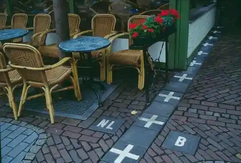
The technical border itself is defined on concrete painted with white crosses that traverse toward the next town, bringing to mind a playful hopscotch rectangular line. It passes through establishments. Here’s a cafe where you could sip a cup of joe overlooking another nation.
Slovenian Border With Austria
Of the four countries the Republic of Slovenia shares borders with—Italy in the West, Hungary in the East, and Croatia to the south—the most stunning of all is its northern border. The Republic of Austria stretches up to 318 kilometers of land and river.

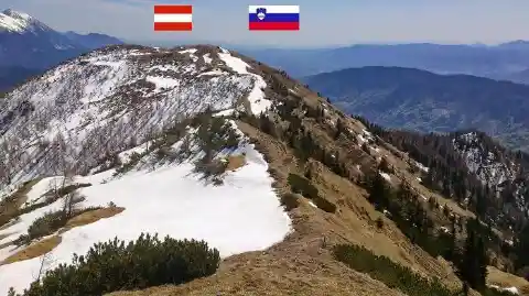
What distinguishes the boundary as defined by the Treaty of St. Germain (and later on in the Austrian State Treaty) aren’t posts or barbed wires—but snow, as white as ice cream, at least when the temperatures are low. From there, one can view the sunny side that is Slovenia.
Hadrian’s Wall
When the Roman emperor visited Britain in AD 122, he commissioned the building of the wall for his safety to keep the tribes and barbarians away during his stay. But this would also serve to keep the Romans from leaving.
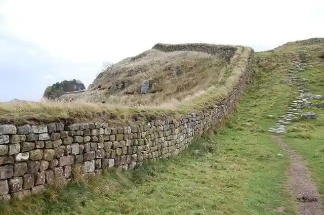
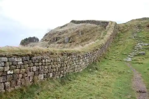
Hadrian’s wall functioned as a defensive framework. Soldiers were sent to monitor the wall, and they were instructed to dig ditches on both sides to make it even harder to breach. This is no longer an international legal boundary today, but it is instead considered a legacy border from times past.
Himalayan Mountain Ranges, China, and Nepal
The border between China and Nepal is 863 miles long. There are six ports of entry throughout the stretch mutually agreed upon where citizens of both nations may enter, and local trade may flourish. There used to be more ports for border crossings, but some of them have closed or are no longer accessible.
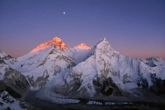

This international border runs through the Himalayan mountain ranges, covering its highest peak, Mount Everest, which is the highest mountain in the world. What an experience it would be, when the weather is just right, to catch a glimpse of this summit point!
Oder–Neisse Line Between Germany and Poland
Without the lessons of history, one could never tell that these two countries that share a common border used to be enemies during the Second World War. The two poles facing each other, painted in their individual nationalistic colors, with Poland’s like a barber’s pole on the beachside, symbolizes the Oder-Neisse Line.
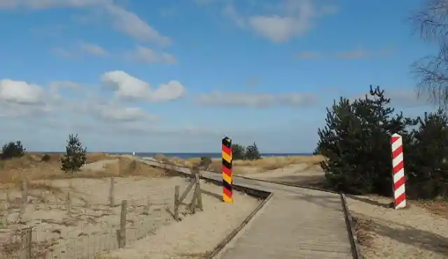
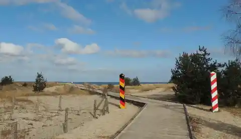
This quaint scene is just a point in the Usedom beach, part of the 286-mile boundary that starts from the namesake rivers and runs to the Baltic Sea. It’s a great spot for a quick stopover before resuming a long drive.
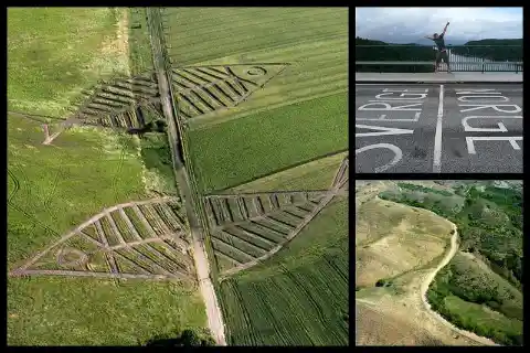
A Big Fish Across the Polish and Ukrainian Border
Travelers to and from the Schengen area will have to cut across vast acreage through the 329-mile-long Polish and Ukrainian border, but there’s no need for a rush. It’s the ideal spot for short stops and taking pictures of its verdant fields that beckon and whistle in the breeze.
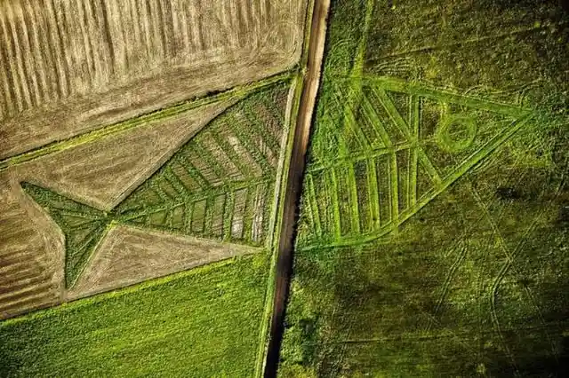
But to truly appreciate its beauty, or its secret message, is through a bird’s eye view. With the eye of a bird, you can see that fish are trying to swim across the fields of Horodyszcze (Poland) and Warez (Ukraine). This is part of the Land Art Festival, created by artist Jaroslaw Koziara, through the mutual cooperation of both countries.
Laos, Myanmar, and Thailand Converge on Two Rivers
These three neighboring countries in Southeast Asia rub shoulders in the rivers of Mekong and Ruak. The former is one of the longest rivers in the whole of Asia, and it’s a popular destination because of its waterfalls and rapids. On the river itself, cruises are on offer—there is a market float as well as a number of fish farms.
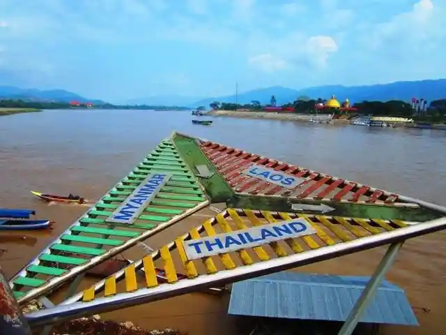

The area is part of what the CIA refers to as the Golden Triangle, which, unfortunately, is not for brilliant or promising reasons. Its neighboring mountains are infamous for narcotics trafficking, and many of the world’s largest drug manufacturers are hidden throughout the 950,000 sq. km. area.
A Plunging Sea Divides Brazil and Argentina
The heart of Brazil oozes fresh water, and along its course, down to its arteries, is a striving jungle with its own distinctive climate from which its unique flora and fauna benefit. It has numerous waterfalls within the Iguazu waterfall system that it shares with Brazil, which is just 16 kilometers away from the dead center.
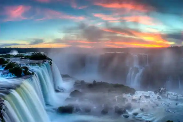

This international border between the two South American countries shouldn’t just be a place for travelers to glide by, but it would need a whole itinerary by itself. It is twice as large as the more popular Niagara Falls.
Contrasting View Between North and South Korea
While South Korea is clearly visible here with its bursting, nerve-like arrangement of electricity and light—the topmost line being the buffer zone between them and their so-called communist state—what darkness flows beyond that line is North Korea’s domain.
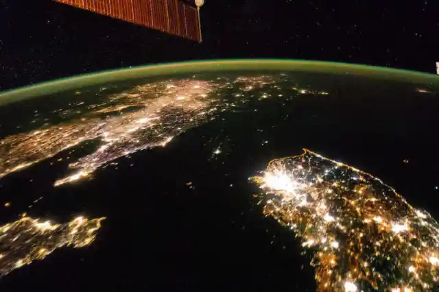

Viewing North and South Korea from space gives us more than just a contrasting view of their geographical location to each other. Their northern counterparts have long been marred with power outages, and it’s reported that most households are only rationed with two hours of electrical power a day.
Tri-Nation Point, Bordering Poland, Germany, and the Czech Republic
These three nations are members of the European Union, meaning they share economic advantages, and their citizens are free to study, live, or work in other member states. Luckily, in terms of travel, going to Poland, Germany, and the Czech Republic, one can simply cross a bridge over a brook.
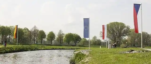

It is quite literally a stone’s throw away, with flags flying on each other’s corners. There are plans to construct a round bridge over the area of their convergence to symbolize their friendship.
Political Border Between Israel and Egypt
Peaceful relations between Egypt and Israel have prevailed for over four decades, and part of what keeps that intact is a straight line that is so defined that it can even be seen from space. Shot from the International Space Station, the stripe can be seen with Gaza in the middle, cutting through the city of Rafah.
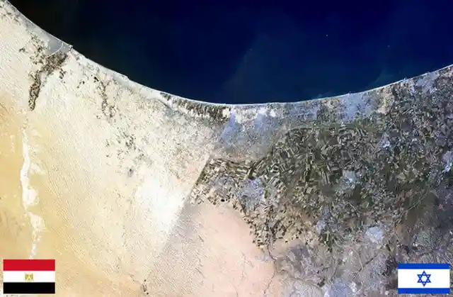
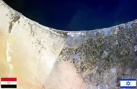
Israel has built a 152-mile fence to limit the entries to the Gaza strip that have resulted in countless armed conflicts, including terrorist attacks. Such a hardline stance on the part of Israel is part of their “hard separation” principle.
Open Border Between Galicia (Spain) And Portugal
Citizens of both Spain and Portugal are free to travel to each other’s territory at any time. Those who are traveling up Portugal’s northern region may cross the Spanish border through a remote area called Galicia, which is known for its vineyards.
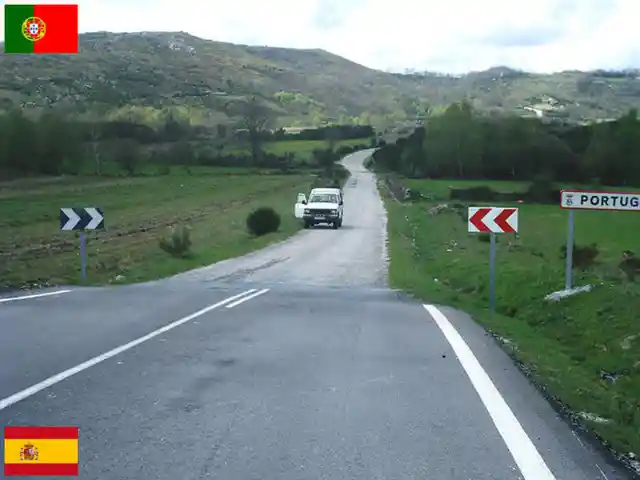

So while traveling to Spain, a good deal of tourists prefer to take their time at the border crossing to take pictures of the quaint place and to go wine tasting. There are a number of vineyards along the Minho River, too. Galicia is also known for its seafood and liquored coffee.
National Park Bordering Germany and the Czech Republic
It’s easy to wander off and get lost in the vastness of the Bavarian Forest National Park, which has an area of over twenty-four thousand hectares. You wouldn’t know that you have crossed the border between Germany and the Czech Republic.
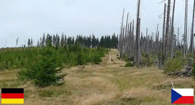
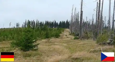
Historically, this is Germany’s first national park, touching the Czech Republic through Bavaria’s eastern section. Hiking through the woods can be arranged while border crossing, where tourists may experience rare animal sightings, like the red deer or the Eurasian Lynx.
World’s Longest International Boundary
When people talk about what borders the United States and Canada, the cool and fresh image of Niagara Falls quickly cascades into the mind of someone who loves to travel. But there is also the international border, which is almost 9,000 km long.

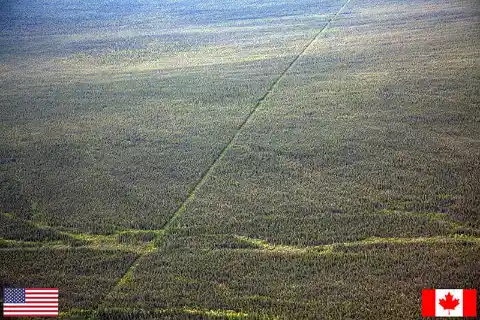
It jumps high up in the mountains, drifts into rich thickets, swoops down lakes, and crosses this faraway prairie. Because of the stable relations between the two neighbors, and a more equivalent economic standing, you wouldn’t see military personnel guarding their border.
Tri-Border Between the Netherlands, Belgium, and Germany
The European Union member states have been working closely on their mutual relations for decades. Where their territories meet, a mountain stands like a cake to celebrate their friendship, apportioned according to their respective domains.
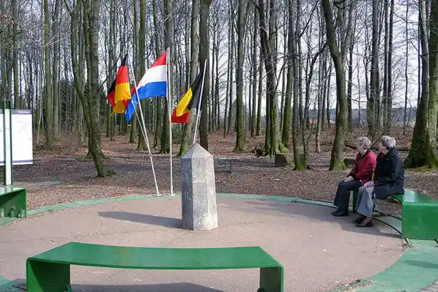

The tri-border point stands at the Drielandenpunt in the town of Vaals, which is also the highest point in Holland. The three flags stand at a pocket park where people often go to amble in the shade of the trees. Within the vicinity are a 34-m high glass skywalk, a 50-m tower, and a popular labyrinth for tourists.
National Border Between Norway and Sweden
Driving through various points of the Norway-Sweden boundary, travelers will barely notice a line on the road that symbolically divides the two nations: a small concrete roadside marker. The better the relations between neighboring countries, the less militarized policing there is on borderlands.

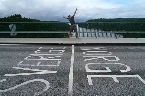
In the case of Sweden and Norway, both being part of the Schengen Area, authorities agree to take turns in individually monitoring their border crossings, where one acts for the other. There are no immigration controls here, only customs checks since only Sweden is a member of the EU.
Traveling to Denmark, Sweden via Øresund Bridge
The majestic structure of the ØResund Bridge visibly arises from the Swedish coast but appears to not make it, like a stride that fumbled before it could actually land on the Danish side. It dives into the ØResund strait below Peberholm island. The Drogdentunnel completes its connection underwater.
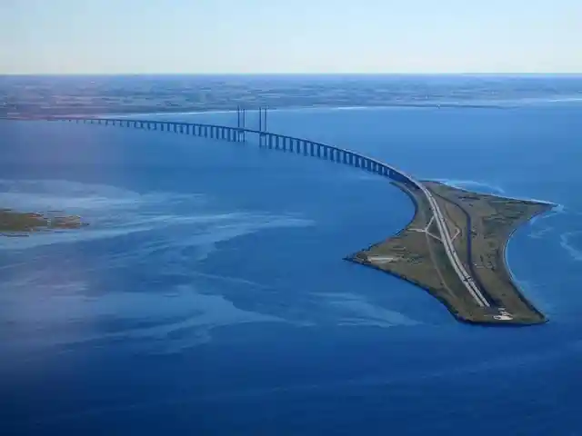
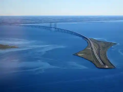
The design of the bridge allows ships to pass the channel regardless of weather conditions, and it prevents the occurrence of ice jams that could lead to upstream flooding. The bridge is designed for both motorway and railway travel.
The Border Wall Between the United States and Mexico
The border wall between the US and Mexico stands in contrast to all the natural borders between countries with beautiful earth formations or bodies of water. The international border is more than 3,000 km long. From the Pacific Ocean, it journeys through urban places, mountains, and desert areas before it reaches the Gulf of Mexico.
A border fence reinforces part of the border. This was initially started under the Bush administration to stop illegal migrants from crossing and illegal drug trafficking. It’s one of the most heavily guarded borders in the world.
Bolivia-Brazil, From Pantanal to the Amazon
This is an aerial view of the Bolivian border with Brazil that starts from the Pantanal in Mato Grosso do Sul to the Acre state, which used to be part of Bolivian territory but was exchanged for fair compensation in the Treaty of Petropolis because its population was mainly Brazilian.
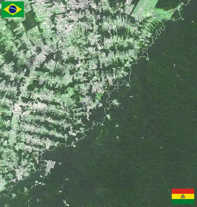
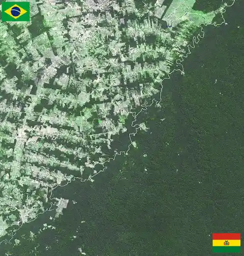
The boundary between the two countries grazes along the Amazon Rainforest, the most biodiverse rainforest in the world, whose borders are also shared by multiple nations like Ecuador, Venezuela, and French Guiana. Brazil and Bolivia are great jump-starting points for great outdoor activities like Piranha fishing or river cruises.
Lótus Bridge Between Macau and Mainland China
When people speak about mainlanders, it specifically excludes those living in Hong Kong and Macau—territories under colonial rule when the People’s Republic of China was established. Macau still maintains a broad, albeit still limited, degree of sovereignty under the “One Country, Two Systems” principle.
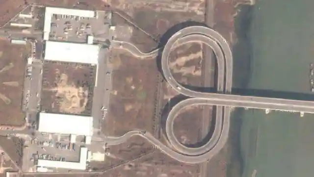
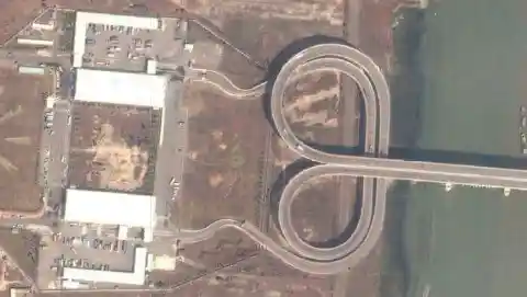
Geographically, the Macau and China border is linked by the Lótus Bridge, which is passable at any time of the day. Motorists drive on the left side of the highway but are made to switch to the right side as they approach mainland China.
Brazil, Argentina, and Paraguay Converge on the Triple Frontier
Thankfully, these three South American countries have maintained friendly relations. Otherwise, there would be trouble on the Triple Frontier. This convergence of both the Iguazu and the Parana rivers is unofficially referred to as the T River.

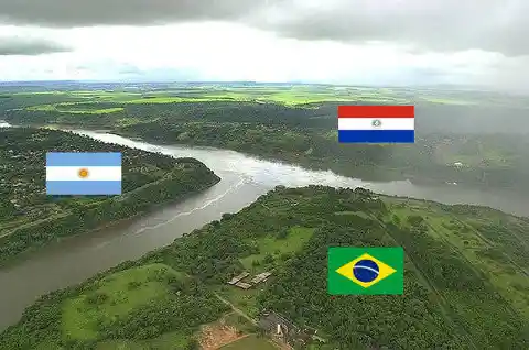
From each of their corners can be found obelisks painted in their respective country’s colors. There’s also a bridge nearby that people can walk across with a scenic view of the borders linking Brazil to Argentina.
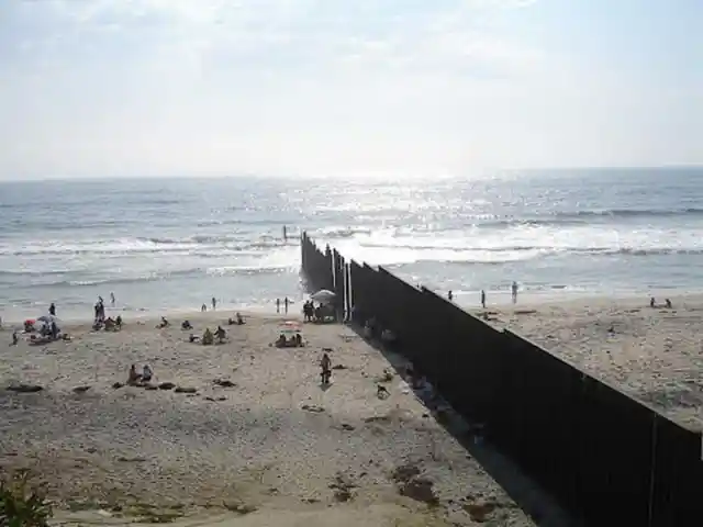
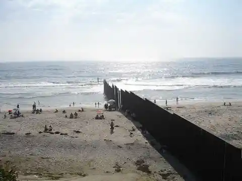
US and Mexico Border in San Diego and Tijuana
From the desert and the mountainous regions, the US and Mexico border, which is among the longest borders in the world (ranks 10th), slices through the urban setting of San Diego and Tijuana. Although the US Border Patrol heavily monitors the manufactured wall, an average of half a million illegal entries have been reported yearly by people trying to cross the United States.
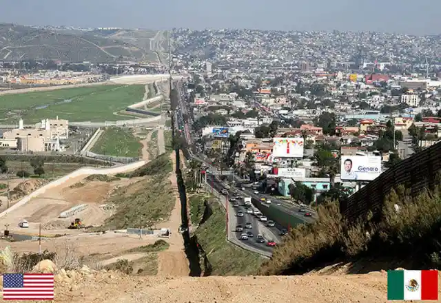

From the right side of the border, the Mexican city of Tijuana is heavily cramped with buildings and road traffic, in contrast to San Diego’s vacant lots. This is just before the border reaches the Pacific Ocean.
Zipline From Spain to Portugal
This is a great example of an awesome border-crossing activity. So much so that some people might jump back and repeat it. From the Spanish side, at the Sanlúcar de Guadiana, tourists armed with passports are able to fly-fox to Portugal through a cable wire, a glide that will last for half a minute.
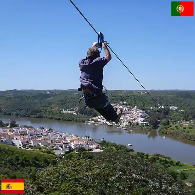

This is the only zip line border crossing in the world. It crosses the Chança River, where people go on boat trips, and the banks have restaurants where tourists and locals mix for sumptuous meals.
Australia’s Natural Border
Unlike in many countries where their governments will have to spend millions of dollars on building and maintaining artificial political borders, Australia is isolated from the world by the Pacific and Indian oceans. These maritime borders also make it referred to as the world’s biggest island.
Consequently, people who travel to Australia are drawn to it because it is famous for its beaches and great outdoors. It has almost twelve thousand beach destinations with its long and beautiful coastlines, and tourists just love its weather.
Boundary Between the Dominican Republic and Haiti
The border between Haiti and the Dominican Republic has a storied past, entailing conflicts with France and, later, with England, which attempted to take over the island of Hispaniola. Even the United States once gained control over Haiti and the Dominican Republic.
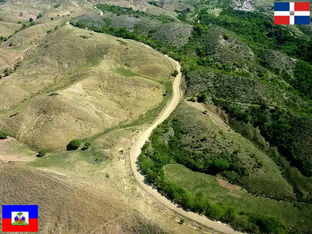

The border runs through many rivers, like the Dajabón and the Libón Rivers. Both countries have agreed to build a wall across their border—an ongoing project—To contain illegal immigration. It is patrolled on both sides.
Snowmobiling in Between Sweden and Norway
Other border crossings between Sweden and Norway had been previously mentioned, but none of them are as cool as this more than a thousand-mile trail in the middle of the forest that has become to nature-lovers and thrill-seekers. It’s a one-of-a-kind snowmobile and snowboarding route.
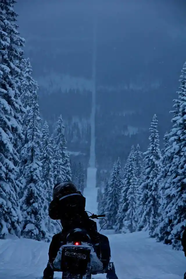
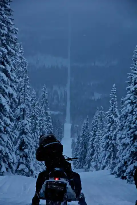
But those who make an effort to bring their snowmachines to the border will have to do so with precaution. Since Norway (on the right) doesn’t want its wildlife to be disturbed, it has passed a law banning the operation of snowmobiles. Sweden, on the other hand, doesn’t mind such activities at all.
Szoborpark, a Tripoint of Slovakia, Austria, and Hungary
Border crossing doesn't have to be a dull, passive drive where people in vehicles just can’t wait to get it over with so they can arrive at their destination. Those who travel between Slovakia, Austria, and Hungary have a chance to sit in those three countries simultaneously.

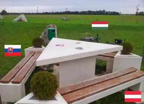
The tripoint border of these places is at the Szoborpark, where sculptors from different countries have displayed their work. Travelers are encouraged to stop over, stretch, and have their meals in the sculpture park built in 1991 following the fall of the Iron Curtain.
A Wall Between Two Towns
There used to be a time when residents of Naco, Arizona, and Naco, Mexico, could just walk across the street to buy goods from a local store or other establishments that catered to both towns without much fuss. But that changed in the 1990s when a 14 ft wall was built to enforce the US and Mexico border.

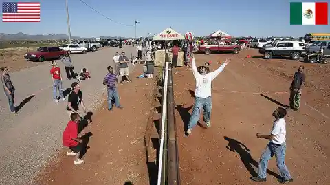
But community members of both places still find a way to keep their friendship from being interfered with by politics. Every year, as a mark of their good relations, they play volleyball at the fence during the annual Fiesta Binacional celebration.
Isebania, Border of Kenya and Tanzania
The most practical way to reach Tanzania from Kenya, or vice-versa, is by air. But the whole experience doesn’t come close to traveling by land in terms of fun. The trip may take around 15 hours, but you wouldn’t be able to put a price on the view of the safari you’ll be witnessing along the trip.

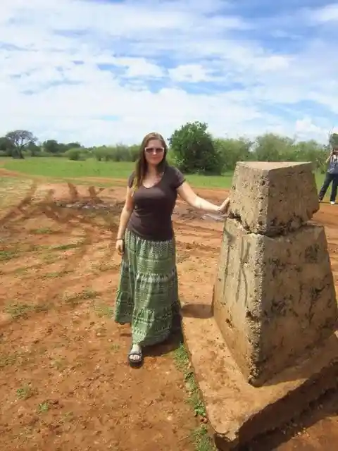
Those who travel in private vehicles stop by at the concrete marker in Isebania, and tours can be arranged around the place, which may proceed by foot, on horseback, or by a safari vehicle. Aside from its diverse wildlife, the Ngorongoro Crater and Lake Victoria are the best places to visit.
From The Alps to the Mediterranean, Italy’s Border With France
The border between Italy and France is 515 km long, and it begins from a point in the Alps and covers its highest peak, Mont Blanc. It is also among the highest in the world and crested with an enduring ice cap. It plunges down to the south into the Mediterranean sea.
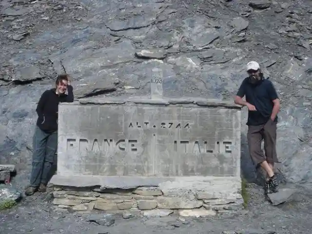
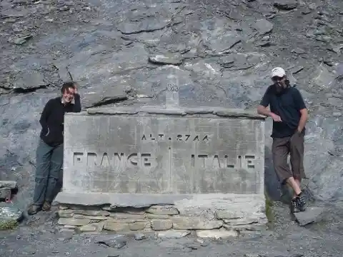
The two neighboring nations used to be in conflict during the Second World War, and there were numerous fighting close to the border, including Italy’s major invasion in the Battle of the Alps in 1940.
Switzerland’s Open Border With Liechtenstein
Also located in the broad Alpine region is the Principality of Liechtenstein. It is a ministate that is almost as big as Washington DC, with only a population of around 39,000. It is a sovereign state similar to Monaco, Palau, and the Vatican, and it shares an open border with Switzerland.
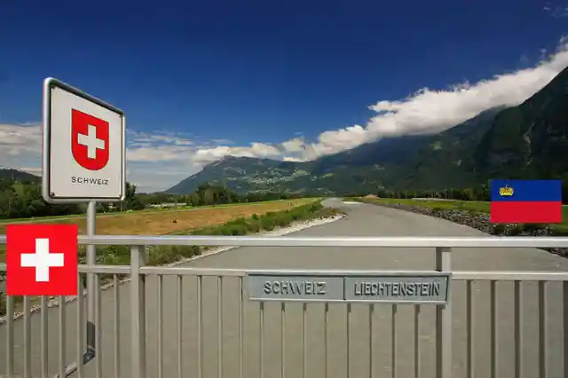

The two neighboring states don’t consider themselves much different from each other. If their border crossing serves anything, it is to symbolize how alike they are in terms of the values they uphold as well as the economic interests they share.
Borders Within Cyprus
The island country of Cyprus evokes imagery of Aphrodite, the Greek goddess of love and beauty, and it’s home to many beautiful beaches that are among the cleanest in Europe. But its violent history caused by the 1974 military junta, which was followed by the Turkish invasion, left the small country with its vestiges in the form of internal roadblocks.

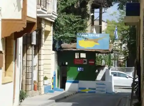
These roadblocks are an eyesore to tourists, and there are seven points that people may traverse from one side to the other. As long as travelers have EU passports, there are no restrictions imposed by either government.
Scenic France–Spain Boundary
There are no security or customs checkpoints along the border of France and Spain since the latter also shares one of its borders with another Schengen country, Portugal, and two other European states. The absence of restrictions encourages its respective citizens to go out and travel.


And there is so much to see along the way. The border is close to the eastern Pyrenees, Cerdanya valley, and the Cadí-Moixero Mountain. It’s a scenic route for bikers, and the view of the mountains while drinking coffee in the town of Perpignan is splendid.
Post WW2 Border of Slovakia and Ukraine
Ukrainians may enter neighboring Slovakia through three border crossings. Since the Russian invasion began, Slovakia has been a crucial ally to them by supplying goods and weapons to Ukraine, which is only less than 100 km from its border.

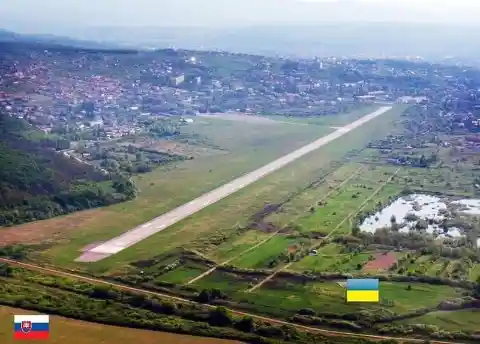
Just outside of Slovakia's doorstep is the Uzhhorod International Airport, which began flight operations in 2016. What makes this setup unique is that a special agreement between the two nations had to be made since aircraft coming from the airport would have had to trespass Slovakian airspace otherwise.
Alaska and Canada Land Border
Although Alaska is technically a part of the United States, Americans cannot get there without crossing Canada. This means that travelers from the contiguous US will have to pass through two borders, thus, should be ready with the necessary ID and documents.
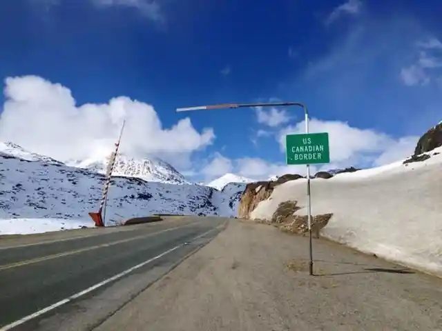
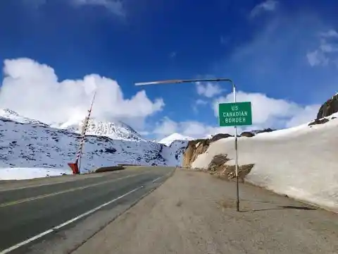
And while it is perfectly all right to drive all the way there, one must take time to plan things out because it covers a total of more than 2,000 miles. That would take many driving hours in the cold, and during winter, the roads are surrounded with snow for as far as the eyes can see.
Haskell Free Library Along Quebec and Vermont
The Haskell library stands on the border of the United States and Canada in Quebec and Vermont, but its construction is no accident. What’s funny about it is that readers coming from the Canadian side will have to cross to the US side to get inside the library.


Conversely, Americans who intend to read or borrow a book there will have to come out at the back door and step on Canadian soil. Since its books are arranged on the Canadian half of the building, conspicuously marked with a black line on the floor, it’s jokingly called “the only library in the US with no books.”
Travel by Road on Karakoram Highway, Pakistan and China Border
At more than 15,000 feet, buses can be found at intervals slowly negotiating the icy route of the Karakoram mountain range to and fro Gilgit City (Pakistan) and Kashgar (China). Land travelers cross the two countries’ international borders at the Khunjerab Pass.
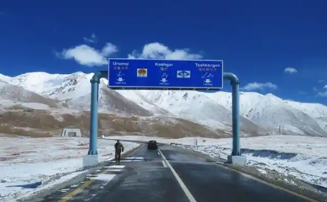
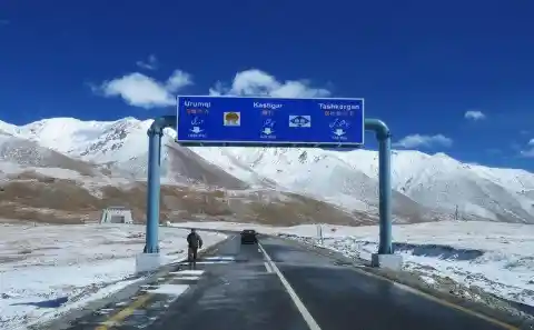
The border pass is located at the highest point of the highway, where commuters can view the mountains covered in snow. When they approach the Chinese side of the territory, vehicles are made to switch to the right side of the road, and vice versa. The highest automated teller machine in the world can also be found here.
Fishing at NW Angle, Between US and Canada
When the Americans and Canadians were writing the Treaty of Paris at the end of the American Revolution, the authorities needed to define the border between the US and Canada. The border was defined using the Mitchell map. The Mitchell map, however, wasn’t detailed enough, showing the Lake of the Woods as oval and smaller. This is how The Northwest Angle became part of the US.

The Northwest Angle is a favorite site for fishermen. In addition, you can get to Manitoba from the NW Angle, but first, you must stop at a small booth called Jim’s corner. That tiny house is a reporting center with phone connections to US and Canadian customs and border patrol.